---top---
Jordan river, gulf of Aqaba, lake Malawi/Nyasa all part of the Great Rift
sea of Galilee/Kinneret/Kinnereth/ Genesaret 702 feet below sea level
rift falley
(Avalon Beach Church)
Galilee, Jordan, Dead Sea
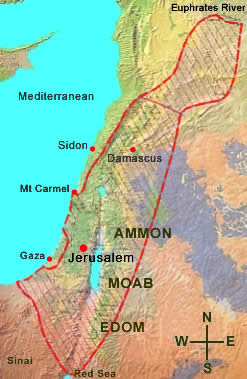
Bible History: Nations and Giants in Ancient Israel: map, Torah/Biblical quotes roughly 3KBCE - 1KBCE
Israel Maps (c. 1700BCE-)
map Biblical Israel
Biblical Israel (snagged 2015-08-02) From the Mediterranean coast to a point on the South edge of the Sea of Galilee/ Genezereth/ Tiberias/ Kinneseret/ Chinnereth/ Kenret at the Jordan river is 50-55 miles (i.e. the distance across Galilee). From the Jordan (between the Salt/Dead Sea & the Sea of Galilee) to Easternmost Israeli lands would be about 17.5-25 miles.
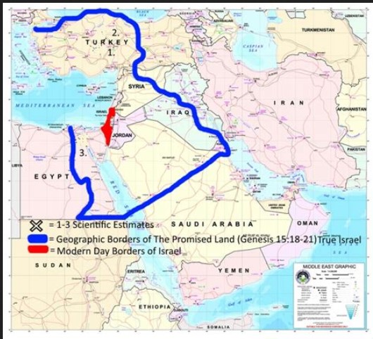
map Israel: Biblical borders: Genesis/be Rashith & Exodus
map Biblical Israel
Biblical Israel (by Abraham bar Jacob c. 1695BCE) (at Jewish Virtual Library)
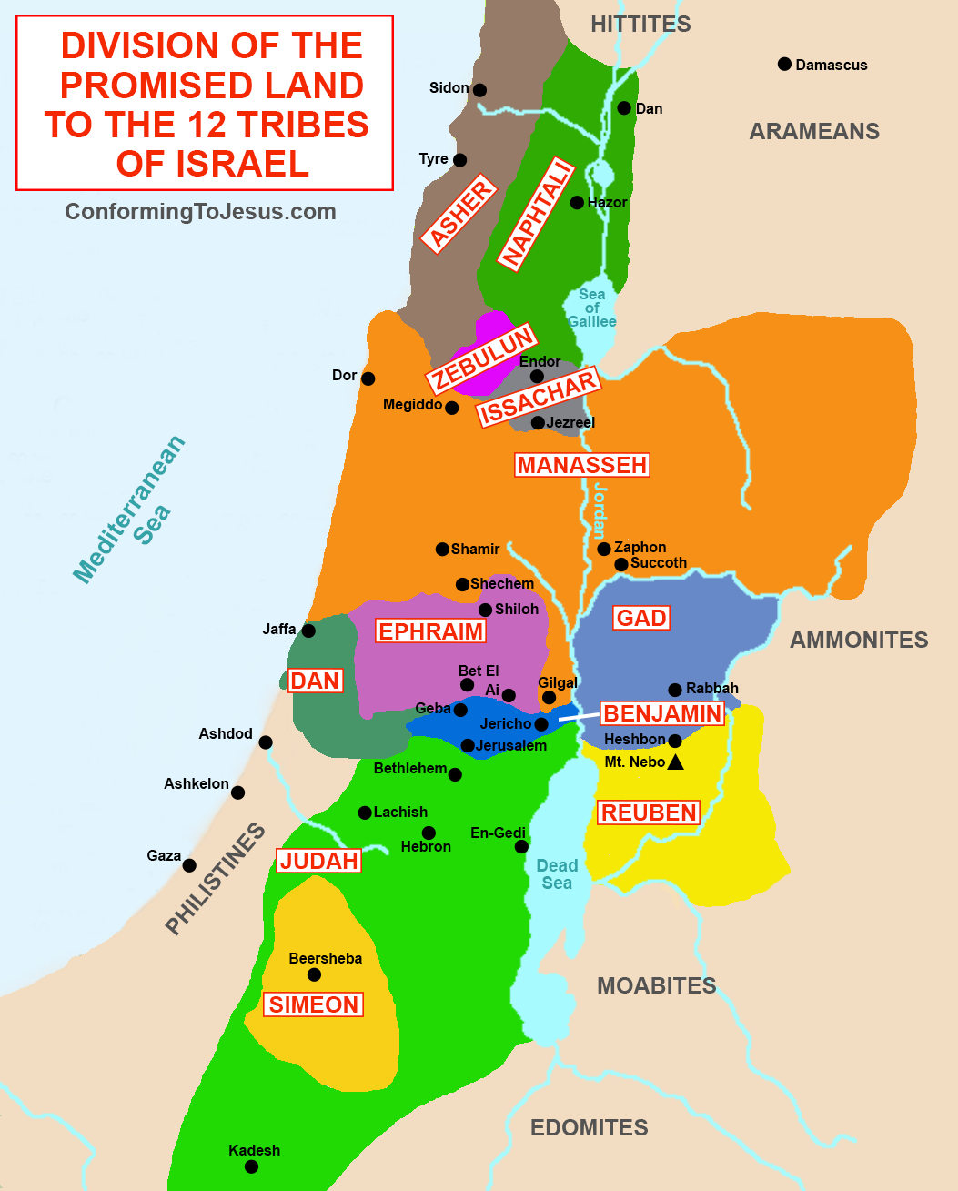
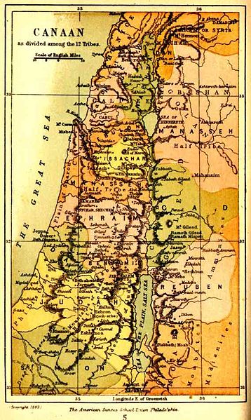
(Conforming to Jesus) division of the promised land to the 12 tribes of Israel (hmm, they have Asher in the area of Phoenicia/Lebanon, & the Edomites/Idumea to the SE of the Dead/Salt Sea)
(Real Clear Bible) another attempt at mapping the 12 tribes, from the Mediterranean to the Euphrates
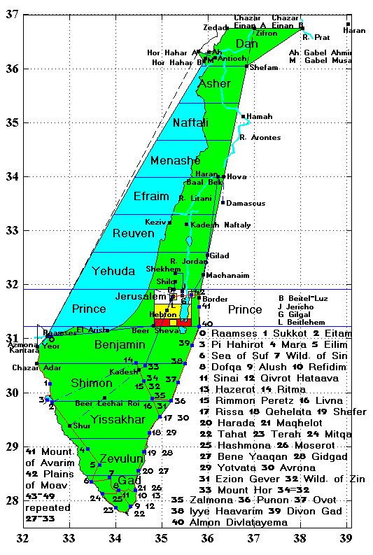
(Bible.CA) 3 maps by Joshua Divides, Steve Rudd; 12 tribes based on Joshua/Yahushaa 13-22 c. 1400BCE or between 1355BCE & 1245BCE (2406AM & 2516)
(Truth of Land.co.il)
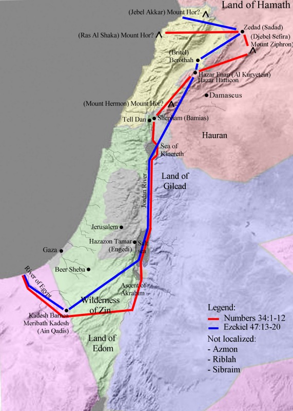
side-by-side comparison maps of Joshua 13-19 with Ezekiel 48
(Pinterest) map based on Jeremiah or Ezekiel
(HaMikdash.ucoz.com) map based on Ezekiel 48
(History Files) time-line with maps: small city-states founded by Hittites/ha-Cheti from Hattusa in Anatolia/ Asia Minor/ Turkey/ Armenia c. 1500BCE
map Biblical Israel (F)
map Biblical Israel (F) (snagged 2011-09-23)
brief history of Israel 1000BCE to 135CE (History to Israel)
map Israel 915BCE
map Israel 915BCE (snagged 2011-12-09) (there are the Palestinians/Philistines occupying the coastal area of Judea/Judah from Joppa/Jaffa down to the Egyptian Sinai border; about 67% of Israel is East of the Jordan river; Lebanon/Phoenicia starts North of the Sea of Galilee/Chinnereth, about even with Kedesh & Einan reservoir, slightly above 33 degrees North; the city of Dan East of Tyre, Mt.Hermon, Damascus, but today we can see a chunk of the Golan heights has been taken from or ceded by Israel)
map Zone for Zion
(GoodWill Ambassador)
(Scripture Essays.org) the world of Ezekiel/Yechezqal (note that North is upper-left rather than straight up; Anatolia/ Turkey/ Asia Minor is labeled Lydia; part of Ukraine is upper left corner; the Southern tip of the Caspian Sea is depicted above Median Empire; the Gulf of Arabia is center-right)
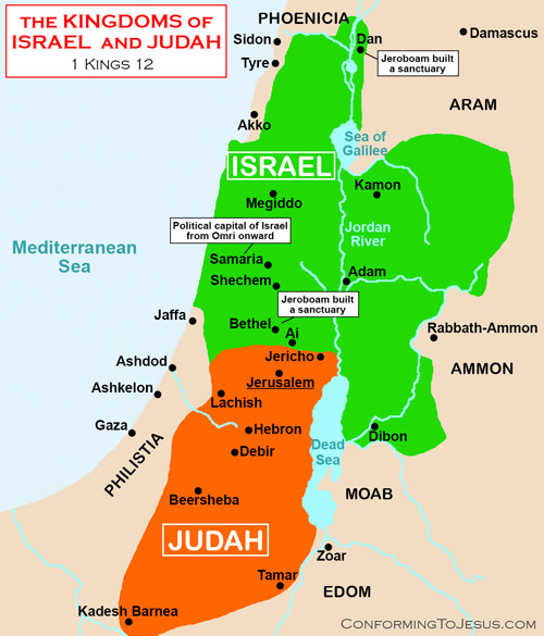
(Conforming To Jesus) post-Solomon = alef Kings 12 with the Northern border of Judah/Yahudah/Judea North of Jericho, and Israel above that and extending some 30 miles East of the Nordan river between the Sea of Galilee/ Kennereth/ Kinneret/ Gennesereth, and a few miles East of the Jordan river to the North of the Sea of Galilee/ Kennereth/ Gennesereth, and reaching North as far as Damascus
map c. 877BCE-797BCE of Phoenicia/ Lebanon/ Zidonia, Israel, with Edom/Idumea both SW & SE of the Salt/Dead Sea, Philistia/Palestine, etc.
(Facts About Israel) tiny map of Israel
(curtis.loftinnc) Biblical Borders
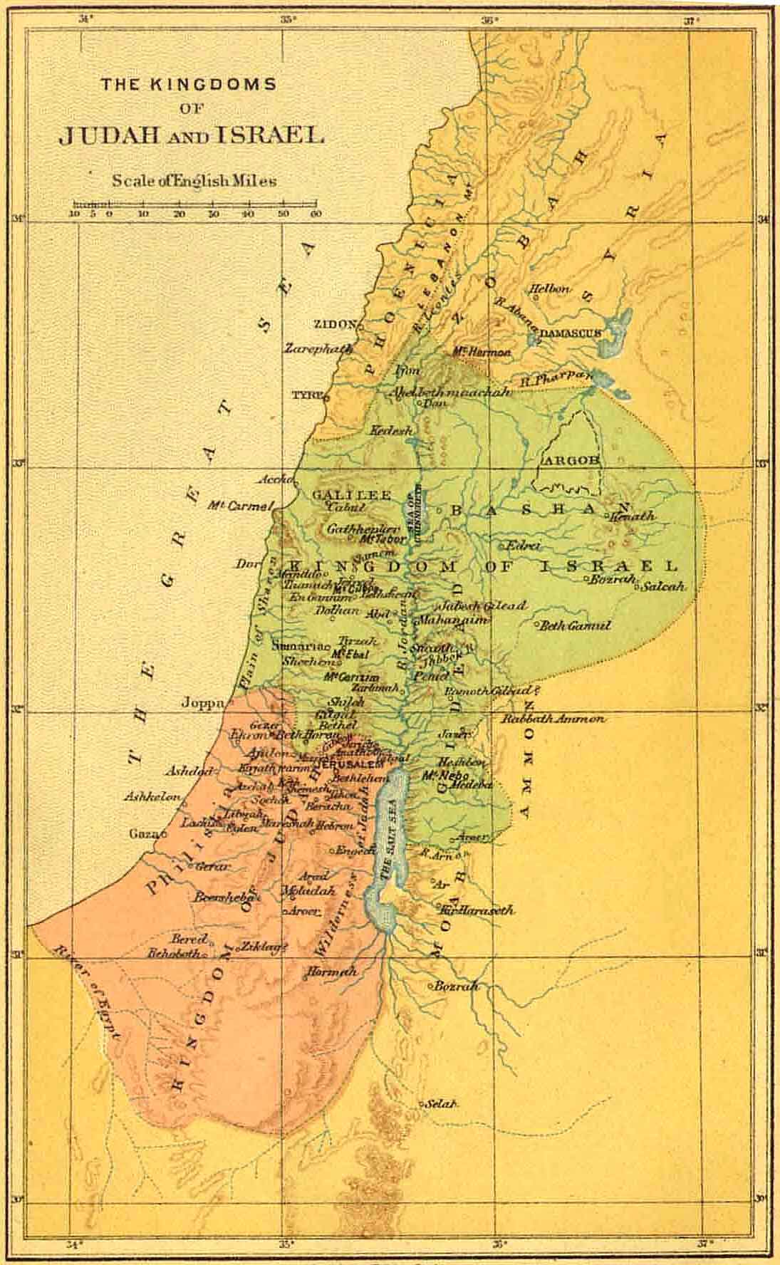
(Bible Mapper) map, split kingdoms of Israel & Judah/ Yahudah/ Judea (alef Kings 12 & beth Chronicles 10)
(Britannica) map: Moab, kingdom in ancient Israel, East of Dead/Salt Sea, from which king David's grand-mother came
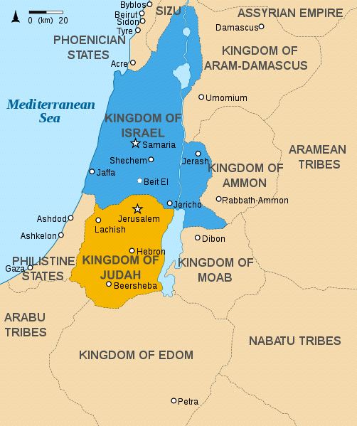
map Phoenicia, Assyrian empire, kingdom of Aram-Damascus, Arameans, kingdom of Ammon, Israel, Judah/ Judea, kingdom of Moab, kingdom of Edom, Philistines c. 830BCE (WickedPedia)
(WickedPedia) kingdoms of and around Israel
(Bible Odyssey) kingdoms of and around Israel
(Bible Odyssey) where was Moab? and Dan up North of Galilee, Cheshbon farther East of the Jordan river than Jerusalem is West... showing paths/travel routes
(Bible Mapper) lands of Gad, Reuben, Moab, Edom shown East of the Jordan river and Dead/Salt sea
(Biblical Archaeology) who were the Ammonites, Moabites & Edomites?
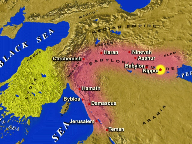
map of Assyria, Babylon, Sumer, Elam, Medes/Medea, Parthia/Parthians, Persians between Persian Gulf and Caspian Sea
map Israel 800BCE (snagged 2011-09-23)
maps of neo-Hittite & Aramean states c. 800BCE (Stephen Batiuk: American Society of OverSeas Research)
map Israel/Judah c. 733BCE
Israel/Judah c. 733BCE (at Jewish Virtual Library)
Israel map 730BCE
map Israel 730BCE (snagged 2011-09-23)
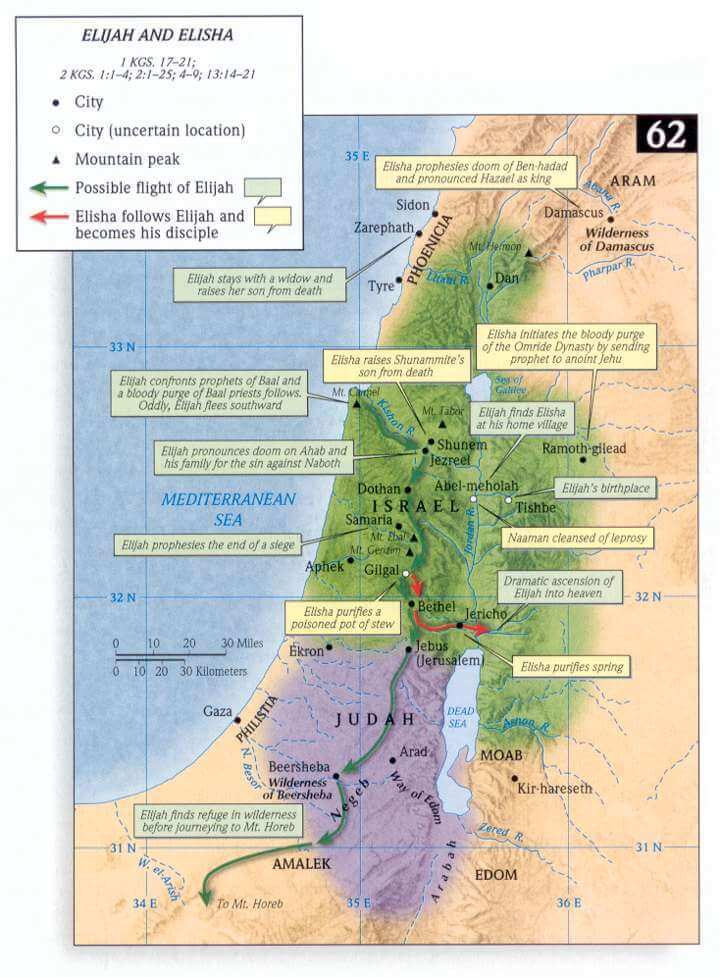
StudyLight: map prophets Elijah & Elisha 713BCE - 662BCE
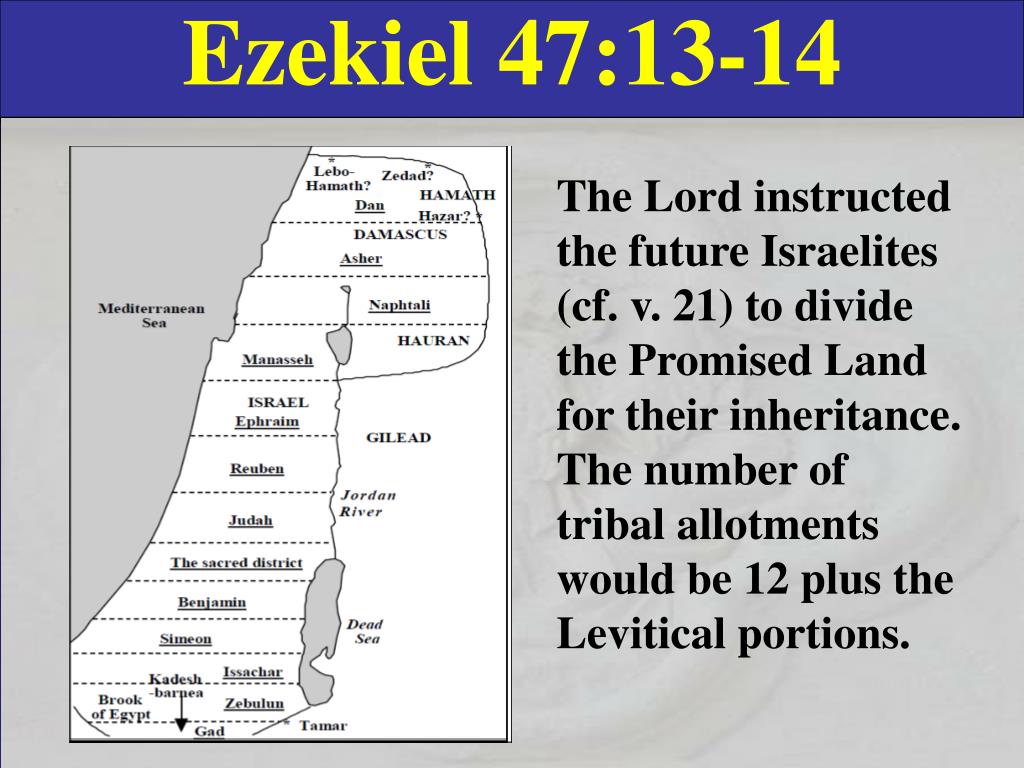
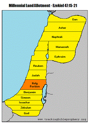
map of Israel based on Ezekiel/ יְחֶזְקֵאל/ Yechezqal 47:13-14 map of Israel based on Ezekiel/ יְחֶזְקֵאל/ Yechezqal 47:15-21 c. 625BCE to c. 570BCE or c. 450BCE to c. 397BCE (c. 3310AM to c. 3364AM) Israel under the Macedonian-Ptolymy dynasty Egyptian empire 240BCE Jewish Virtual Library)
Yemenite Jews archaeologically confirmed 110BCE - 1950CE (legends of proto-Jewish and Jewish residence beginning in a range from 2468BCE to 1450BCE to 500CE)
map: Israel 110BCE
map Israel 110BCE (snagged 2011-12-02)
map: Israel 104BCE
map Israel 104BCE (snagged 2011-12-02)
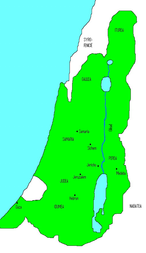
map: Israel 103BCE
Israel 103BCE (snagged 2011-12-02; Syro-Fenicie=Phoenicia=Lebanon)
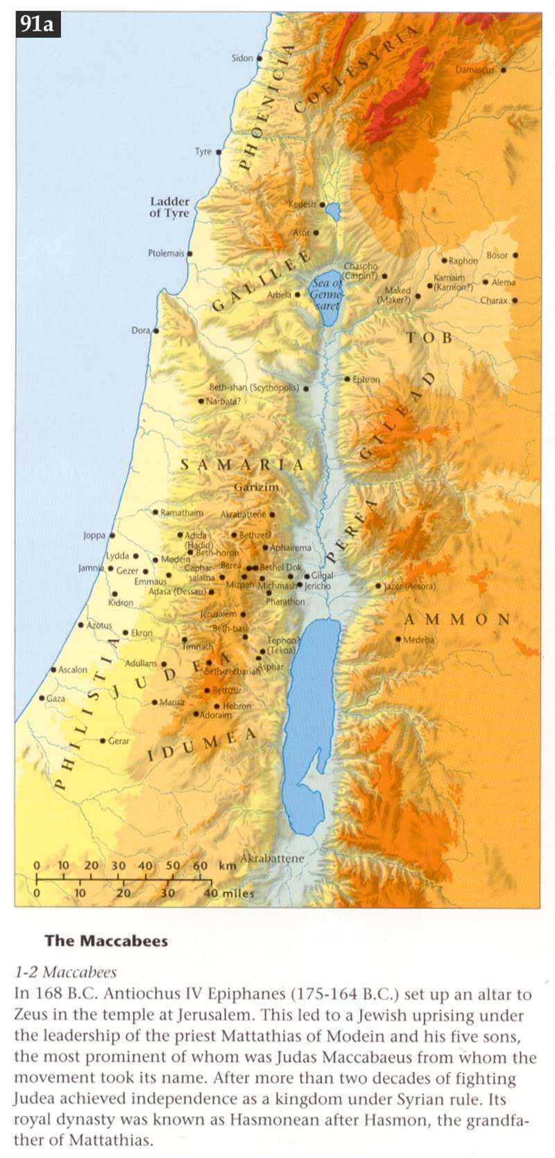
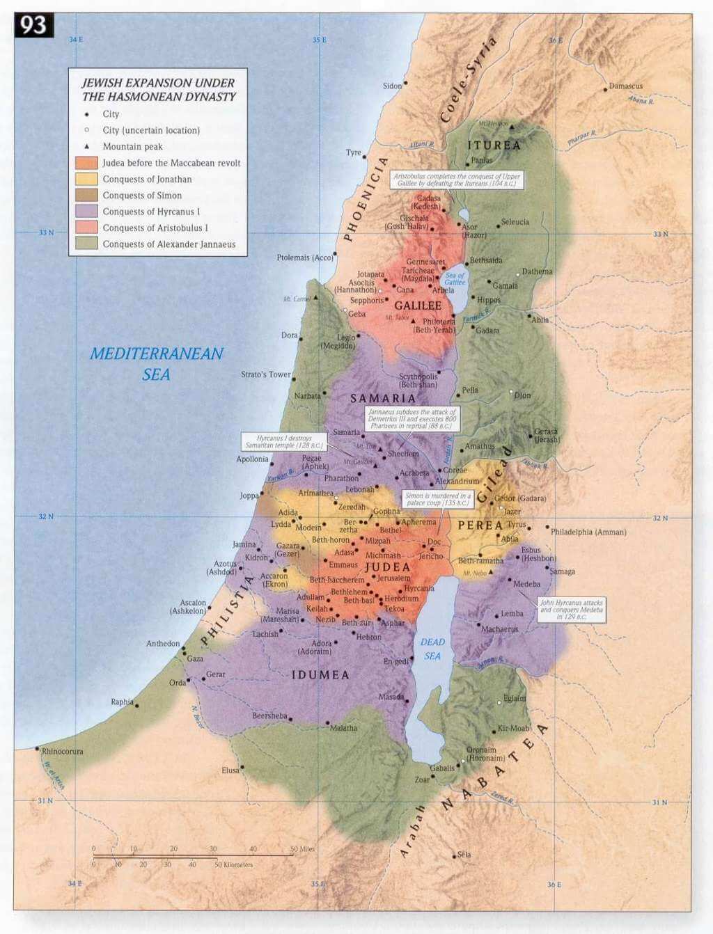
Hasmonean kingdom c. 170BCE-37BCE from the revolt against the Macedonian/ Greek/ Hellenistic/ Ptolemean/ Seleucid empire to the Roman occupation & the Herodian Idumeans & Tzeddekim/ Sadduces/ Boethusians Maccabeean/ Asmonean/ Hasmonean/ Chasmonean Israel c. 167BCE-147BCE (from biblestudy.org)
Chasmonean/ Hasmonean/ Maccabeean Israel 90BCE (Jewish Virtual Library)
map: Hasmonean kingdom c. 170BCE - c. 37BCE from the revolt against the Macedonian/ Greek/ Hellenistic/ Ptolemean/ Seleucid empire to the Roman occupation & the Herodian Idumeans & Tzeddekim/ Sadduces/ Boethusians slightly higher resolution
Maccabeean/ Hasmonean/ Chasmonean Israel c. 167BCE-100BCE
Maccabeean/Hasmonean Israel c. 167BCE-100BCE (from Christians Standing with Israel .org)
StudyLight: map the Maccabeean/ Chasmonean restoration of united kingdom of the descendants of Israel (c. 168BCE)
StudyLight: map Maccabeean/ Chasmonean restoration
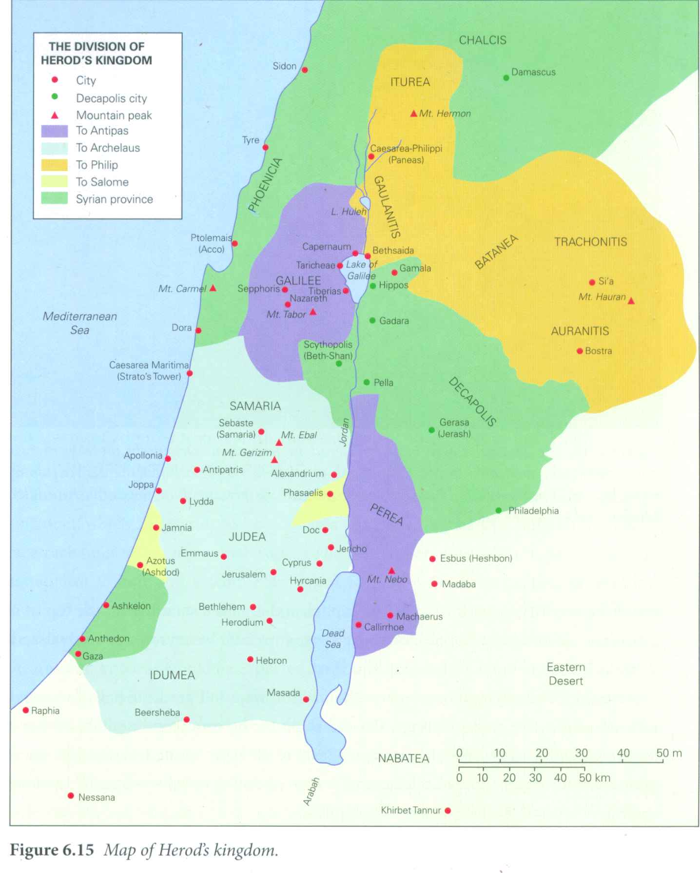
Israel in time of Herod the great c. 73BCE-c. 1BCE
Israel in time of Herod the great c. 73BCE-c. 1BCE (snagged 2011-08-04 from Geza Vermes 2014 _The True Herod_ (170 pages; ISBN 9780567575449; OCLC 870425058; Bloomsbury; 933.05092) (his father was an official in Idumea/Edom/land of Esau)
-----
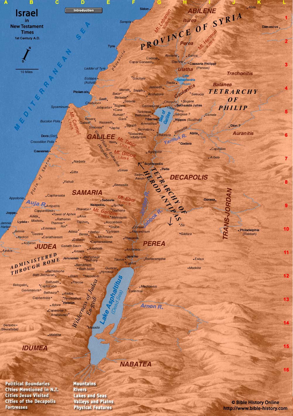
map Israel 0-100CE
Israel 0-100CE (map snagged 2015-08-18)
map 1st century CE (Jewish Virtual Library)
Israel c. 67BCE
Israel c. 67BCE (snagged 2011-12-02)
Biblical Israel (G)
Biblical Israel (G) (snagged 2011-09-23)
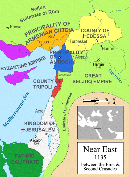
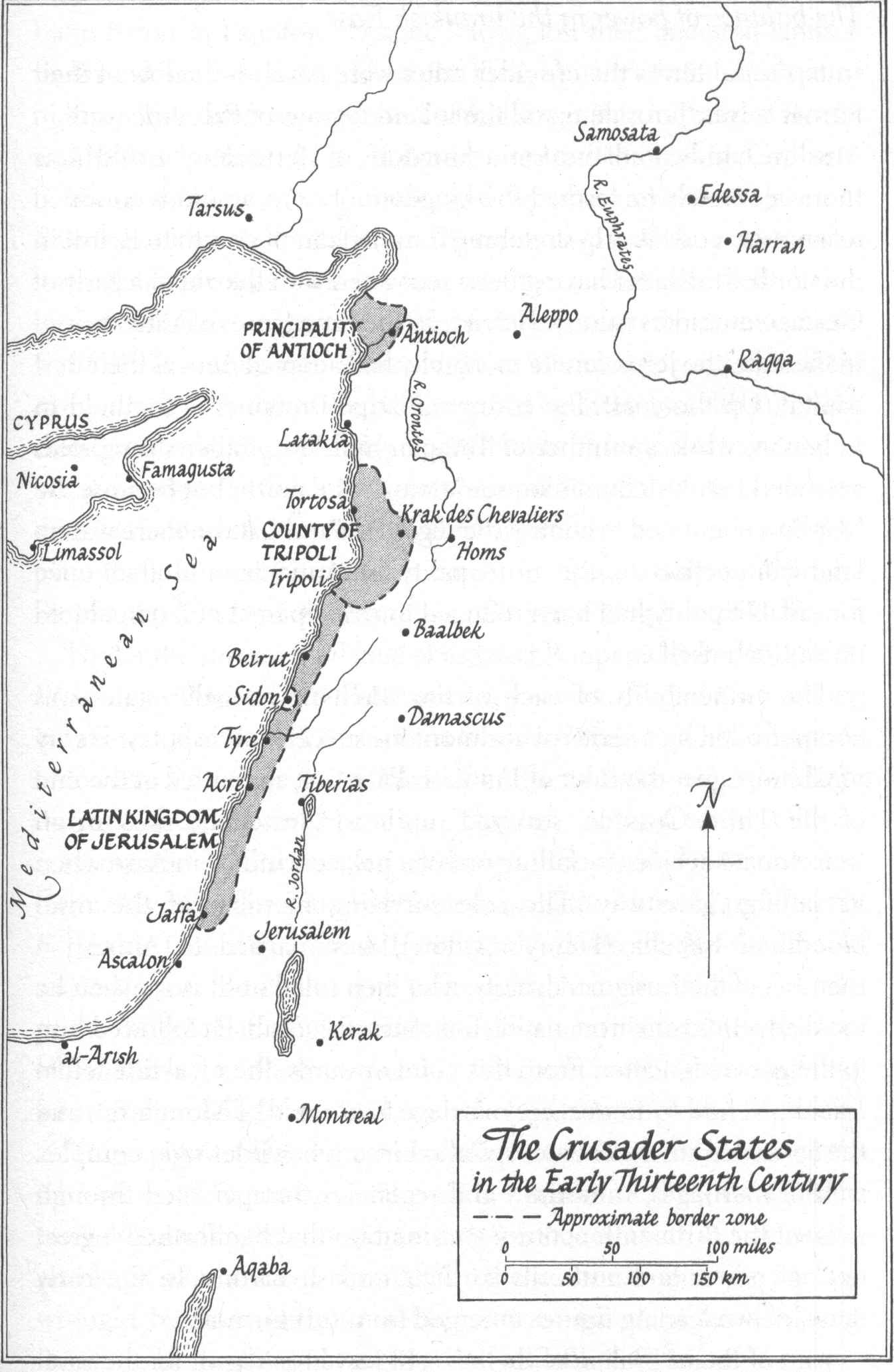
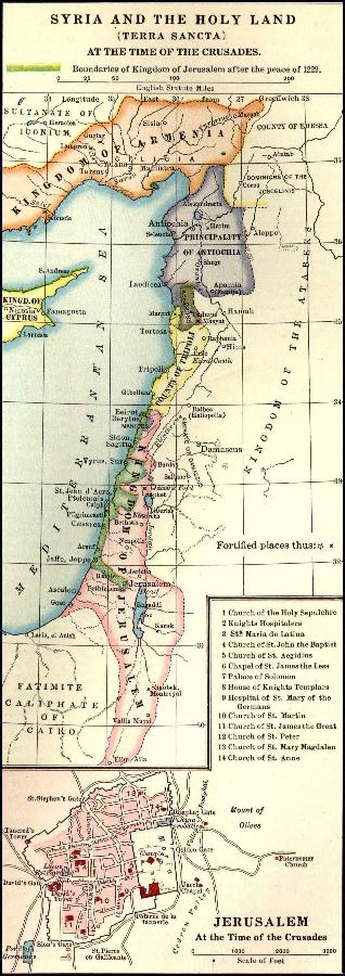
map Israel 1135CE
map Israel 1135CE (PNG snagged 2012-11-20 converted to jpg) (simplified we can see no "Palestine", no Lebanon nor Phoenicia, same old border with Egypt; kingdom of Jerusalem from well North of Sea of Galilee to well South of Ascalon/Ashkelon/Ashqelon, emirate of Damascus is well East of the Jordan, of Dead/Salt Sea, & we can see Abraham's father's place at Harran/Charran North of the Euphrates)
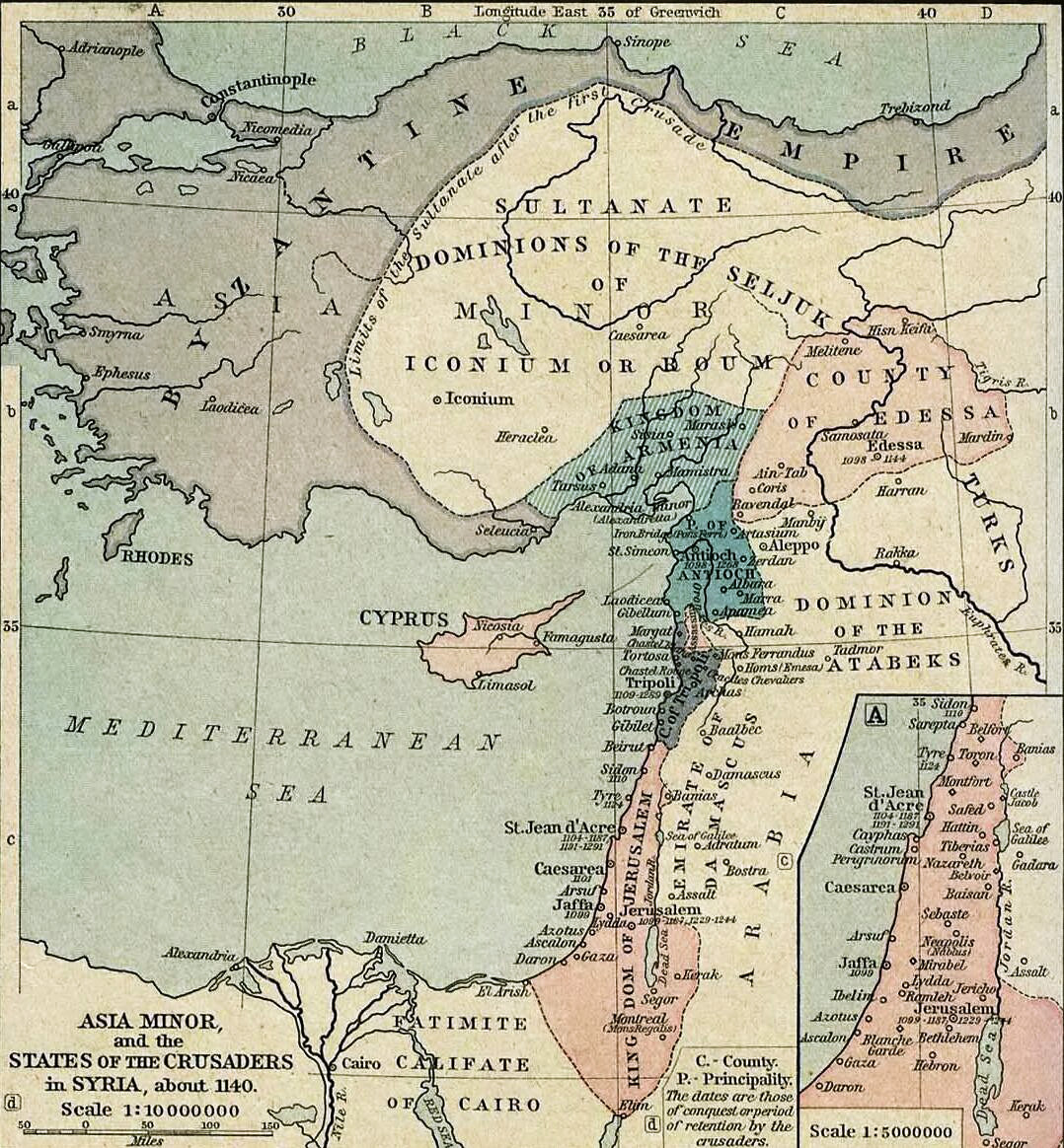
map Israel 1140CE
map Israel 1140CE (snagged 2016-02-05) (no "Palestine", no Lebanon nor Phoenicia, same old border with Egypt)
map Israel 1230CE
map Israel 1230CE (snagged 2012-12-23) (no "Palestine", no Lebanon nor Phoenicia)
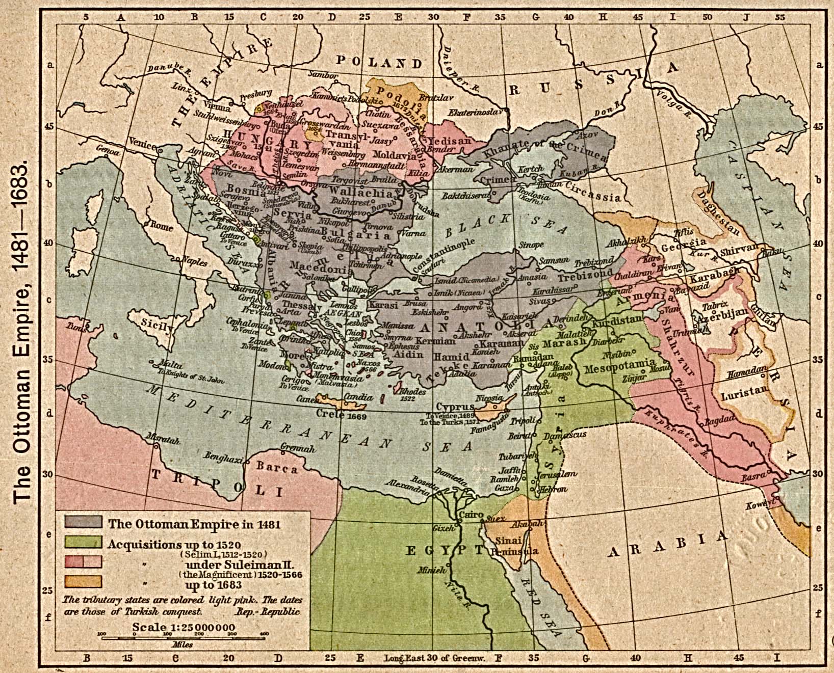
lieutenant Claude Reignier Conder & lieutenant Horatio Herbert Kitchener maps of Israel & Middle East 1880s (David Rumsey) APAAME maps Conder & Kitchener DAAHL (UCSD) DAAHL by time period (UCSD) AIAR library map collection Ottoman empire 1481CE-1683CE (at U of Texas)
map Israel 1486CE
map Israel 1486CE (by Bernhard von Breydenbach) (at Jewish Virtual Library)
new Jewish villages/towns/settlements in Israel 1881-1914
new Jewish villages/towns/settlements in Israel 1881-1914 (at Jewish Virtual Library)
map Jerusalem 1883
map Jerusalem 1883 (at Jewish Virtual Library)
map Jerusalem 1883
map Jerusalem 1883 (at U of Texas)
map Ottoman empire 1914CE
map Ottoman empire 1914CE (at Jewish Virtual Library) and (TimeMaps.com)
map Ottoman empire districts 1915
map Ottoman empire districts 1915 (at Jewish Virtual Library)
1916-05-08, Sikes-Picot wax pencil markup map based on 1910 British Royal Geographical Survey, with rail-ways added in 1915 November (link to politically biased WickedPedia) (Acre/Akko/Aqqa to Haifa in red, part of Israel in Yellow, Lebanon and parts North in blue; Eilat & Aqaba/Akaba at very bottom at red dashed line's Western/Southern = bottom/left at what recent maps label the Gulf of Aqaba. The area labeled "A" must've been their notion of Syria, "B" of TransJordan or some such; Black sea at the top. The Sea of Galilee/ Kinnesereth barely discernible, obscured by intersection of blue line, blue region, yellow region, dashed red line.)
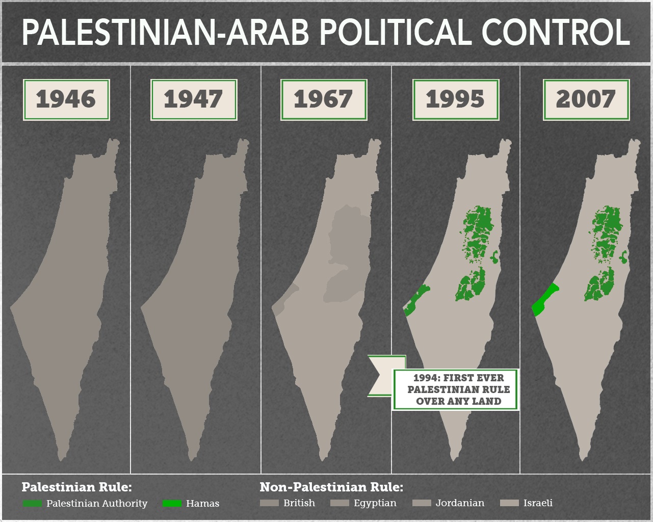
map Israel 1946CE-2007CE
map Israel 1946CE-2007CE (snagged 2015-10-19 from Shany Mor: Tower)
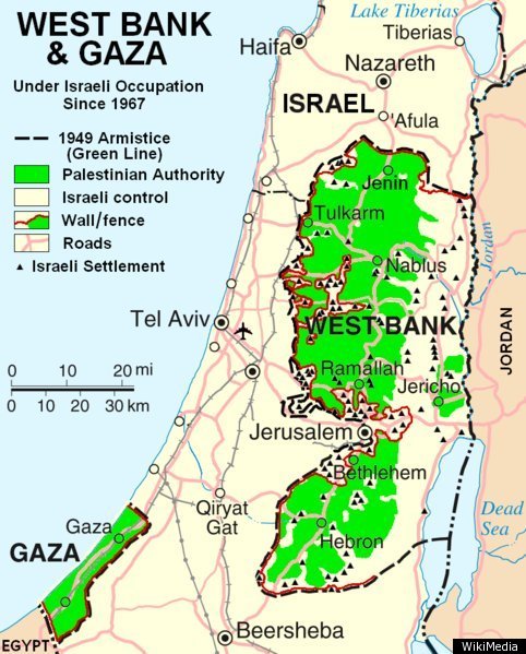
1947-11-29 the UN hatched the scheme to take land from Israel to fabricate the "West Bank"
1948-05-14 at re-establishment of Israel: Egypt, TransJordan, Saudi Arabia, Iraq (all 3 ruled by relatives & associates of a regime created with the aid and guidance of England during WW2), & Lebanon invaded Israel
1949 armistice lines put Palestine=Gaza Strip under Egyptian rule, fictive "West Bank" under TransJordan rule, Syria had made incursions in Galilee, Golan Heights area, leaving several towns occupied
1950-04-24 through 1988-07-31, TransJordan invaded Israel & occupied fictive "West Bank" area of Judea & Samaria, Israel
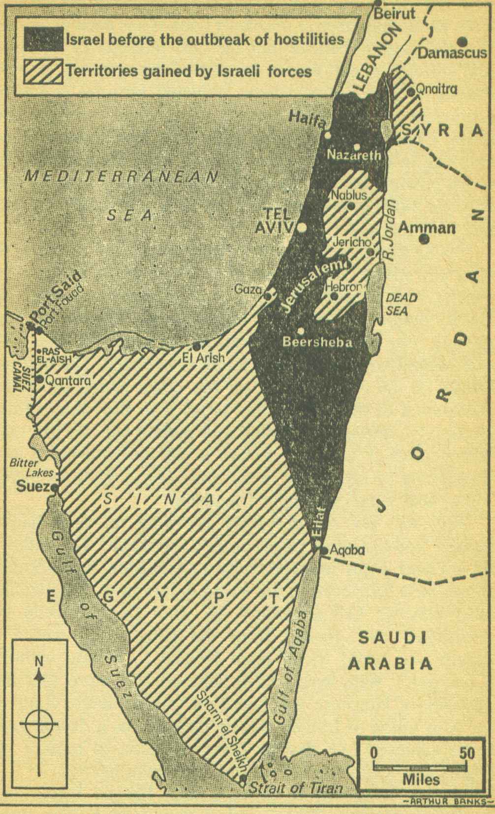
1967-06-05 through 1967-06-10 Israel re-took Israel, Palestine, and the Sinai peninsula... then gave back the Sinai peninsula to Egypt, gave TransJordan the land East of the Jordan river, and set aside Palestine = the Gaze Strip for the "Palestinians"
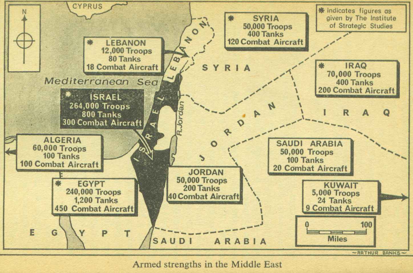
map Israel 1967CE (A)
map Israel 1967CE (A) (snagged 2016-02-02 from Randolph S. Churchill & Winston S. Churchill 1971 _The 6 Day War_ (250 pages); citing Arthur Banks & Institute of Strategic Studies)
2023-11-26: Yehudis Litvak: Aish: the on-going Jewish presence in the land of Israel (part 1)
(part 2)
map Israel 1967CE (B)
map Israel 1967CE (B) (snagged 2011-05-25)
map Israel 1967CE (C)
map Israel 1967CE (C) (snagged 2011-05-25)
map Israel 1967CE (D)
map Israel 1967CE (D) (snagged 2016-02-02 from Randolph S. Churchill & Winston S. Churchill 1971 _The 6 Day War_ (250 pages); citing Arthur Banks)
neighbors wage war against Israel 1973-10-06 through 1973-10-25 after which Israel gave back the Sinai peninsula and Suez canal to Egypt, returned some of the territory after driving back Syria from Galilee
1982, after incursions by Hizbollah & PLO, Israel re-established the border with Lebanon
2021-12-13: Douglas J. Feith: Mosaic Magazine: Hudson Institute: the forgotten history of the term "Palestine" Yes, there was land East of the Jordan river that was part of Israel. That's no longer a point of contention. Yes, the British, in payment for help against the Ottoman empire, gave Iraq and Trans-Jordan to an Arabic family. Most Israelis willingly accept that. The "West Bank", and boundaries of Palestine=Gaza Strip & of Lebanon are where the combat is continuing, with a little terrorism within Israel by occupying "Palestinians" thrown in. President Trump's "Abraham Accords" at least suggested some expansion of Gaza Strip=Palestine to the SE, because there's no way they are going to give up more land closer to Jerusalem & Tel Aviv for Hamas & Iran to base missile barrages. At one point, Israel defeated invaders and pushed them back East of the Jordan, back across the Sinai peninsula. Giving up those areas was a generous concession.
Center for Israel Education: maps 1882-2020
H/T: I found many good maps at StudyLight: pastoral resources: Bible maps archive some of which I have added as links. maps (Jewish Virtual Library)
back up to Top